
Excelsia Studios 1
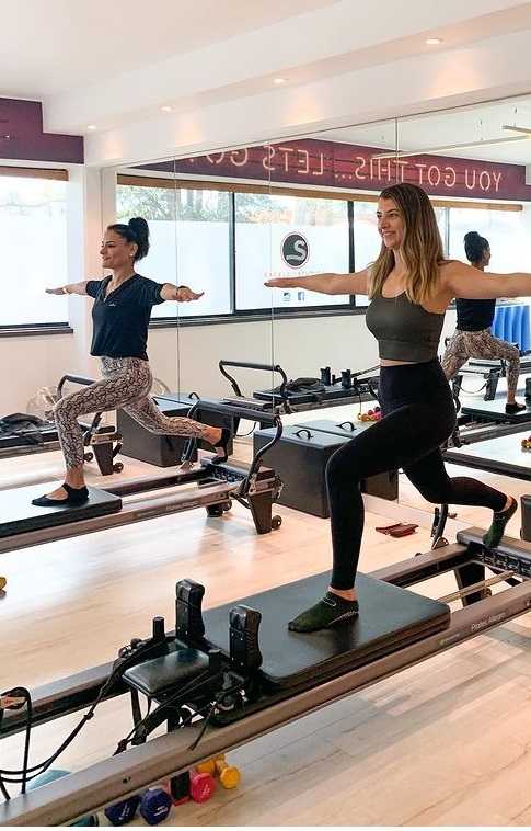
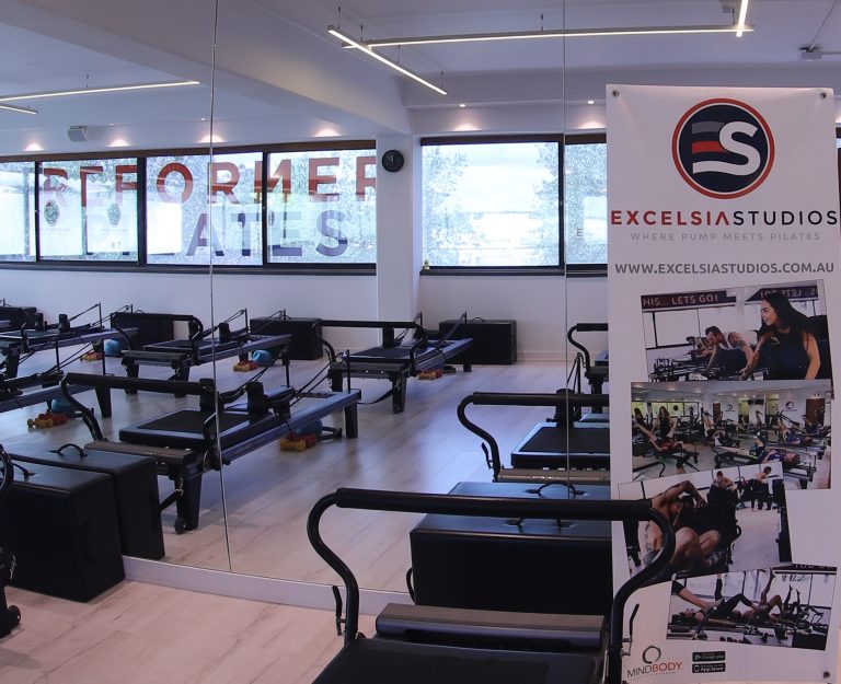
EXCELSIA STUDIOS 1 REGISTER NOW CARDIO CORE STRENGTH FLEXIBILITY POWER FULL BODY FITNESS
excelsiastudiosadvance
EXCELSIA STUDIOS WHERE PUMP MEETS PILATES CARDIO CORE STREGHT FLEXIBILITY POWER FULL Register Now
Excelsia Studios
Excelsia Studios WHERE PUMP MEETS PILATES . CARDIO .CORE .STREGHT .FLEXIBILITY .POWER
Drone services for maintenance and inspection of hard-to-reach areas

Drone services for maintenance and inspection of hard-to-reach areas
With our drones , we carry out professional operations for industry , energy , construction and agriculture . We inspect complex technical structures and buildings for maintenance and control. Our high-resolution cameras detect even the smallest defects and signs of wear. The inspection with drones guarantees you long-term safe operation of your industrial plants. At the same time is the inspection by a drone much easier and time-saving than conventional methods.
We deliver high-resolution images, videos and 3D models that digitally record your objects and industrial plants. We analyze the data, process it professionally for your working environment and deliver the data to you.
Achieve your goals with our visual solutions

360° (spherical) panorama
360 degree spherical or 3D panoramic photography is the interactive viewing of wide-angle panoramic photographs, generally encompassing a 360-degree circle or a spherical view. It is the art of capturing or creating a complete scene as a single image, as viewed when rotating about a single central position. The spherical panorama can be viewed with any computer, smart device or VR goggles.

Aerial 360° panorama
The spherical panorama’s special version which is taken in the air using the lower airspace usually from (GND) 80-150m height. This kind of bird's eye view panorama can provide additional visual information and navigation aid for virtual tours or we can show larger areas such as a town or an industrial plot.

360° video
360-degree videos, also known as spherical videos, are video recordings where the view from every direction is recorded at the same time, shot using either a special rig of multiple cameras, or using a special VR camera that contains multiple camera lenses embedded into one device. During playback, the viewer has control of the viewing angle or direction like a spherical panorama, a form of virtual reality

VR – Virtual Reality
A Virtual Tour is a visual solution where several 3D panoramic photos and other contents (maps, videos or pictures) are stitched together into a complete showcase system. This way more complex projects can be shown while interactively navigating among the virtual content, such as a whole town, part of a city or an industrial property..

Virtual tour
360-degree VR (360-degree virtual reality) is an audio-visual simulation of an altered environment that surrounds the user, allowing them to look around a previously captured 360-degree video or spherical panorama in all directions, just as they can in real life.

Still photography
Beside the 360° photography we take high quality aerial, underwater architectural, portrait or event photos for websites, catalogs, book illustrations, using them printed or in digital format.
Our services
Everything you need at your finger tips

The sewer drone is currently used primarily where entry into the sewer sections of the sewage system is technically not possible, manned due to the risk assessment is not justifiable or not desired, or where the sewer inspection using a camera tractor fails. Deposits, obstacles, damage to the bottom or an increased sewage level in the sewer often lead to the cancellation of a conventional sewer inspection . For these reasons, experience has shown that the inspection of the main collectors, the most important discharge organs of urban sewage disposal, is only carried out sporadically or avoided if possible. The sewer drone can help here.

The drone provides detailed images of the interior. We use the indoor drone , for example, in tanks, silos, sewers, flue gas ducts, cooling towers, hall ceilings, elevator shafts, industrial chimneys, furnaces, gas and steam turbines, boilers and burners in power plants. We deliver high-resolution images and videos of the condition of the interior from the interior areas. In addition, we can document, for example, weld seams, corrosion coatings, screw connections, sockets and brackets as well as inlets and outlets. In this way you will discover corrosion, flaking, cracks or other abnormalities from the drone inspection.

Industrial plants and power plants must be checked regularly. The systems always have areas that are difficult or dangerous for people to reach. With drones we can examine these areas easily, inexpensively and safely. The maintenance analysis is at a high level and enables you to carry out perfect monitoring. With the 360° recording of the entire surface, for example of a cooling tower, you receive data with a very high level of accuracy. Thanks to long-distance data transmission, we can immediately evaluate, process and save the recordings.

The surveying of areas using drones is a simple and precise method that is mainly used in urban planning and urban development. Surveyors no longer have to enter dangerous areas like in opencast mines. You save time and money and increase security. The drone records heavily overlapping photos. These are then combined with photogrammetry software and create a distortion-free and true-to-scale orthophoto and a 3D model .The size of buildings can also be documented in this way. It is also possible that the drone also records facades. In this way, damage such as cracks or fractures are documented. In addition, landfills and heaps can be surveyed with drones and thus inventory changes can be calculated.

The use of drones in the construction industry offers construction companies and engineers great advantages. The construction progress can be precisely documented through precise measurements and the subsequent 3D modeling with photogrammetric recordings . Building Information Modeling (BIM) is the visualization of all systems in a building. The parameters include size, scale, and functionality. Drones realistically depict the situation in a 3D model and superimpose it with the computer-aided design. This makes it possible to check whether the construction corresponds to the construction plans. This ensures the quality of work and helps to react quickly to any deviations. Even before construction begins, drones provide important measurements. Property lines can be clearly identified and the amount of cut and fill for foundations can be accurately calculated using drones.

The possible uses of drones are almost unlimited. SaarDrones has drones that can be used safely even in difficult environments and provide very good data. The use of drones is generally characterized by efficiency and accurate data.
Find Us
As visual information is worth a thousand words, the best way to reach your goals is by appealing to your customer eyes.